Martinsville Conservation Club Easement
The Martinsville Conservation Club Easement has been closed due to some individuals wandering onto the gun range. Due to safety and liability concerns the club withdrew their easement. The KHTA is investigating other arrangements for the connection into Martinsville. Unless otherwise posted private easements are for hiking on the marked corridor. Out of respect for the generosity of landowners who have granted easements, camping or wandering off of the corridor is not permitted.
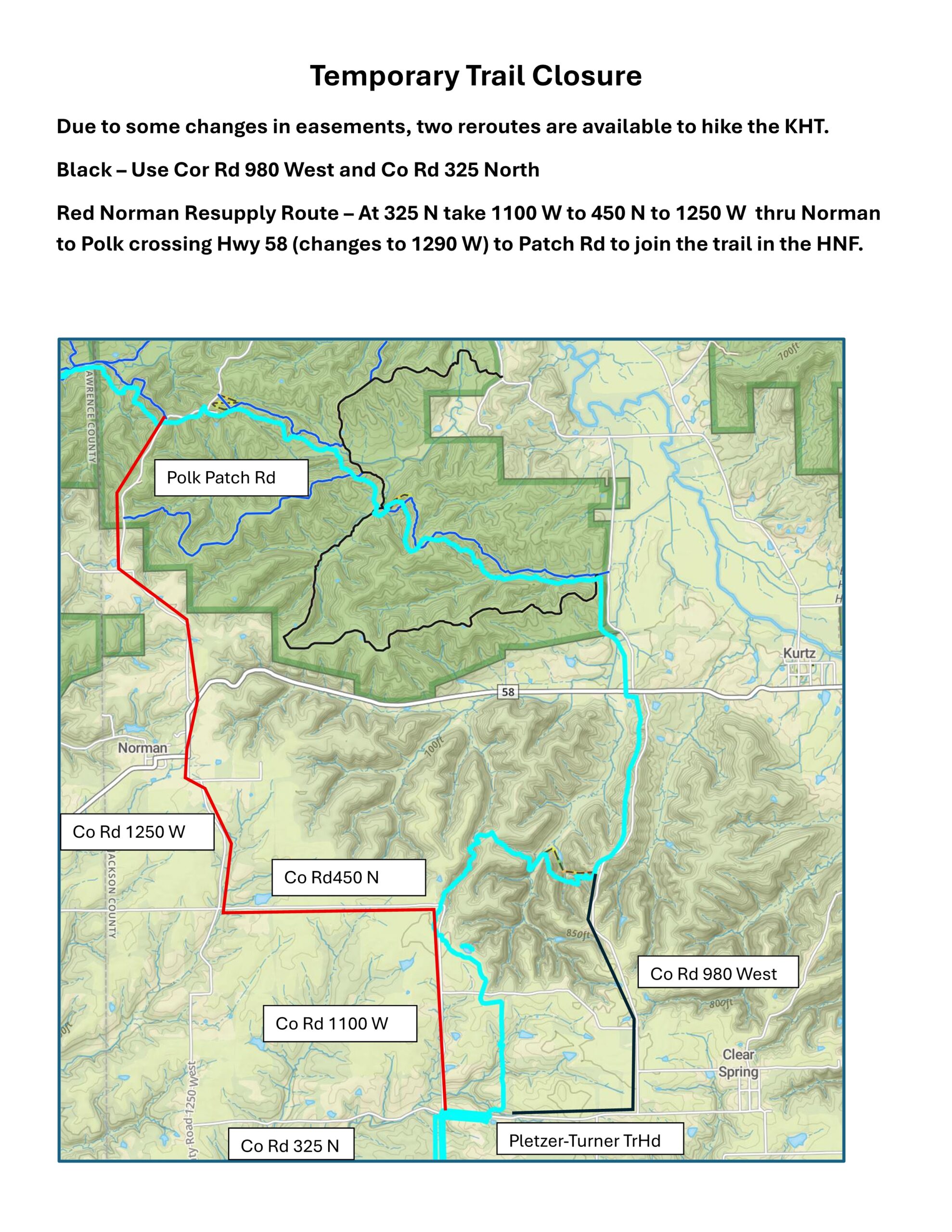
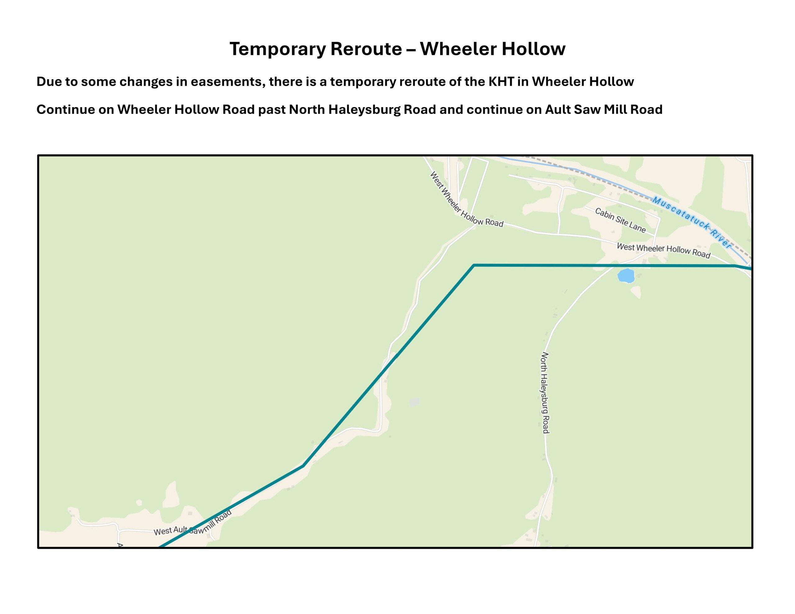
Spring 2026 Reroutes
Due to changes in easement status, two reroutes are posted below.
T
Indian Hill Road Closure
-
Fall 2023 Update
More recently the Brown County Commissioners petitioned the IDOT to reopen the crossing. The IDOT ruled that the crossing can be reopened as soon as conditions are met for its reopening. For detailed info click Here to view the detailed IDOT statement and support documents. As we await further word, all hikers are urged to consider all safety and legal concerns as they hike the Tecumseh Trail.
-
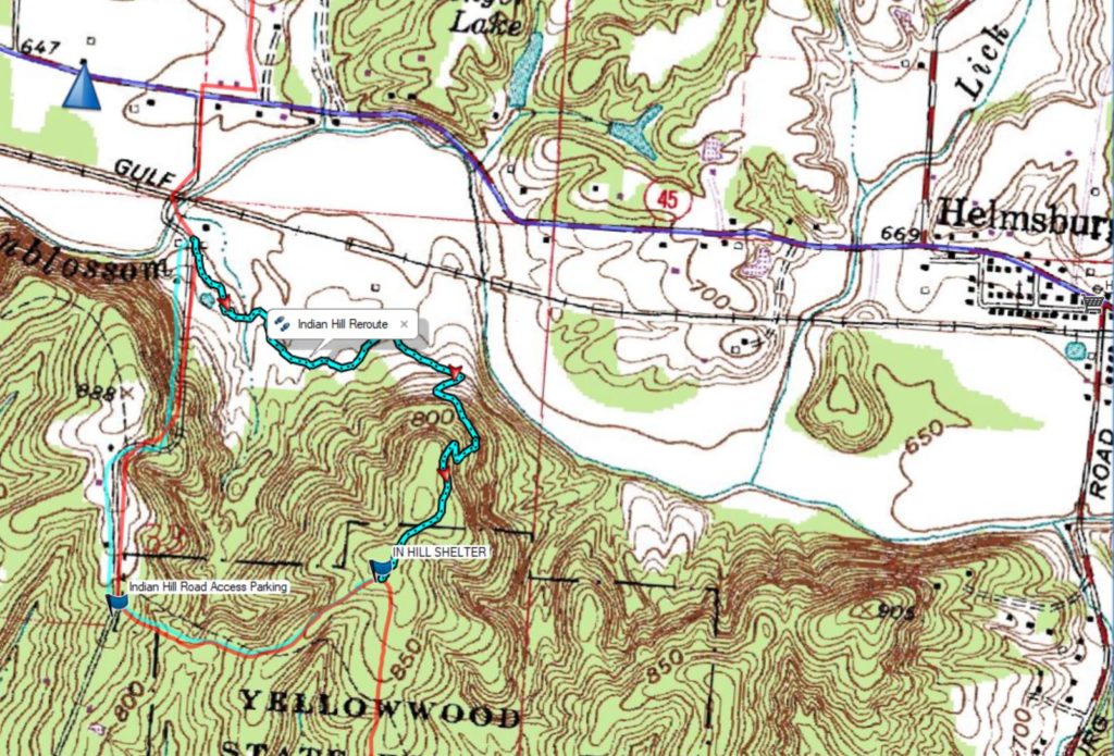
Indian Hill Road has been closed at the rail road track just South of Highway 45. The Yellowwood State Forest posted the following on their website. Subsequently the HHC built the reroute listed above.
Yellowwood State Forest advisories—Due to the unexpected closure of the county road that the
Tecumseh Trail uses to reconnect with state land to the north and because of No Trespassing signs erected by the railroad for public safety, the Tecumseh Trail is closed at the section shown on the map until further notice. (To view the map, click on the blue text)To reach the Indian Hill Trailhead parking lot, drivers can detour via Plum Creek Road. From the East it is best to head South out of Helmsburg on Helmsburg Road and take Plum Creek Road West to intersect Indian Creek Road. From there head North. From the West it is best to take Plumb Creek Road East from the Needmore area. At the intersection of Indian Hill Road head North. Discussions are underway between the rail road and the Brown County Highway department. Hopefully, the road will reopen in the not too distance future.
- The HHC has constructed a reroute around the trail closure at the railroad near Indian Hill.
Thanks to the good work of the HHC there is now an alternative to the long road walk around the closure. Just South of the train tracks there is a trail through the Trevlac Bluffs Nature Preserve to the Trailhead on Highway 45. From there would need to carefully avoid traffic along highway 45 back to the North side of the closure. This reroute adds a little less than 2 miles of hiking. It does offer an opportunity for resupply or refreshment at the nearby Needmore Store a short distance West on Hy 45. You can download this map by Clicking Here.
The Trevlac Bluff Nature Preserve is managed by the Sycamore Land Trust. You can view and save a more detailed map of the preserve at their website by Clicking Here .
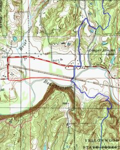
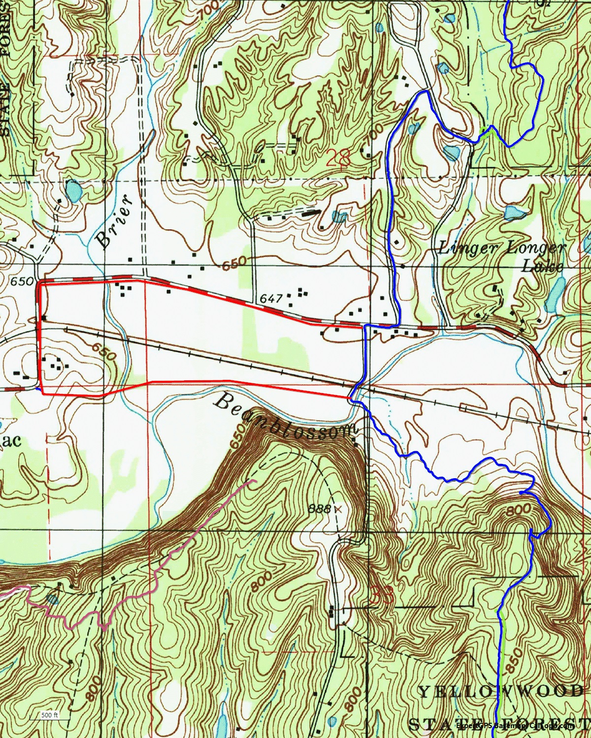
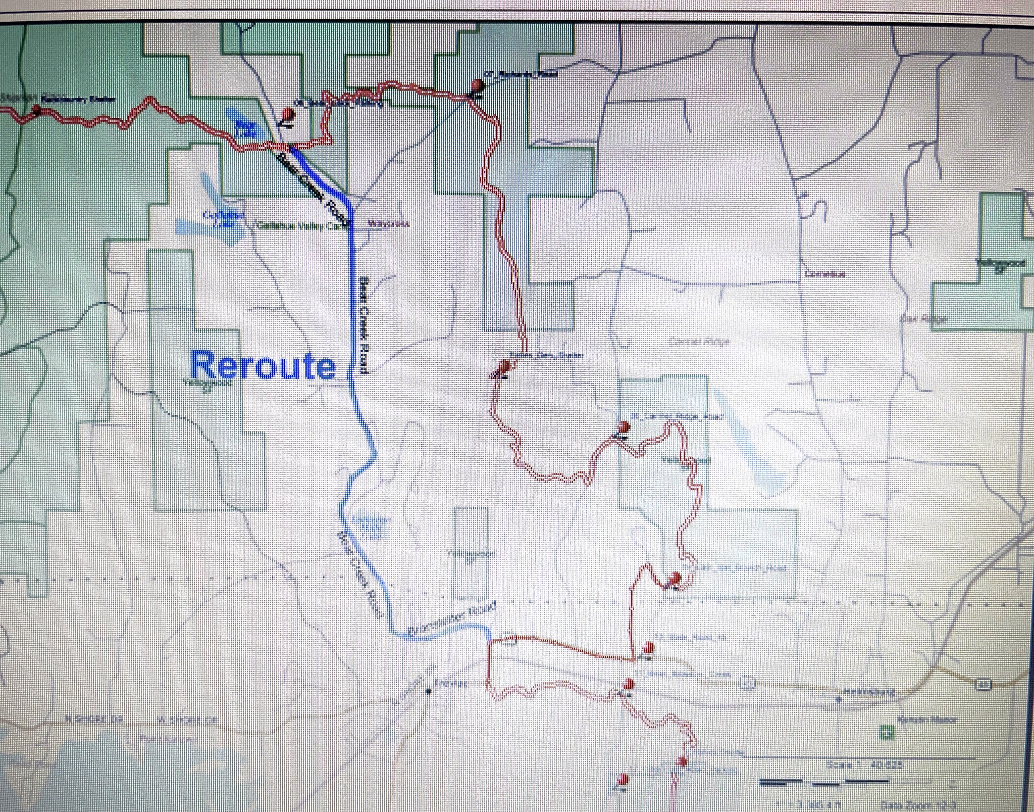
(https://sycamorelandtrust.org/trevlac-bluffs/) - Logging Reroute – The Tecumseh Trail between East Lost Branch and Indian Hill Road is still being rerouted due to on going logging activity in the area. From the corner of Highway 45 directly North of the Trevlac Bluffs Nature Preserve take Branstteter Road West to the intersection of its intersection with Bear Creek Road. From here head Northwest on Bear Creek Road to its intersection with the TT near the Bear Lake Trailhead (KHT mile 143.4) The combined distances of these reroutes is approximately the same as the original route of the TT. To download a map Click Here
A New Restaurant – Unfortunately Mom’s Cafe has closed
Belmont – Hickory Shades Motel – 5714 State Rd 46, Nashville, IN 47448 – 812-988-4694 –  www.hickoryshadesmotel.com – offer pet & bike friendly room from $39 – group rates available – 7.2 miles from Nashville. The hotel also has the on-site Zoo’Opolis Bird Park – (812) 764-4980 – Zoo-OpolisBirdPark@Outlook.com – 5718 State Road 46, Nashville, IN 47448 – Wed, Fri & Sat. 11am – 1:30pm.
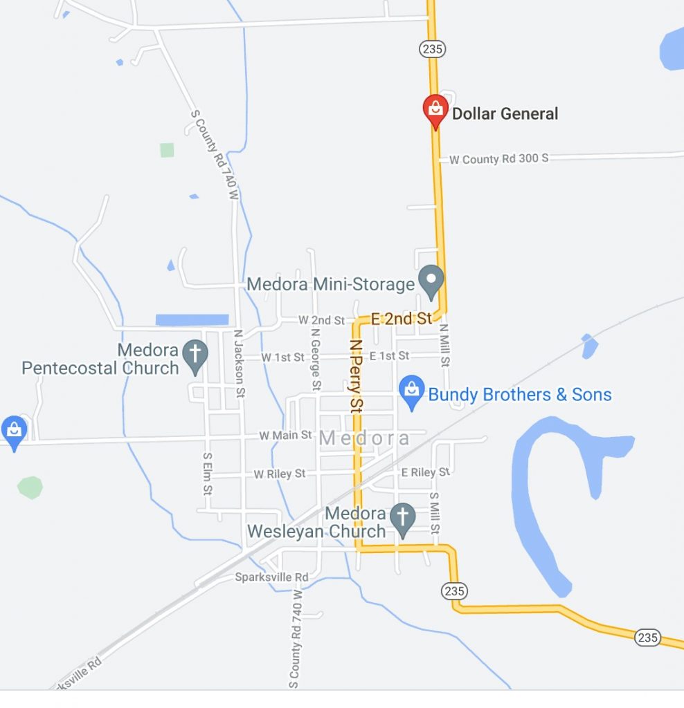
Medora Resupply – A Dollar General Store is now open in Medora at 2953 IN Hwy 235 – 812-966-0840
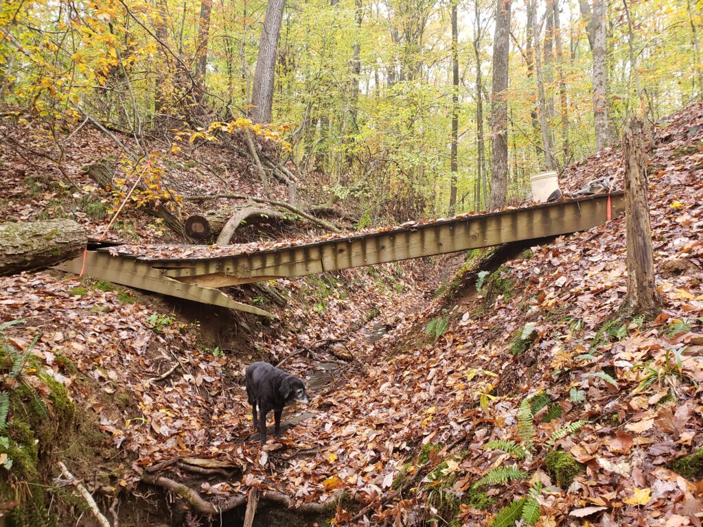
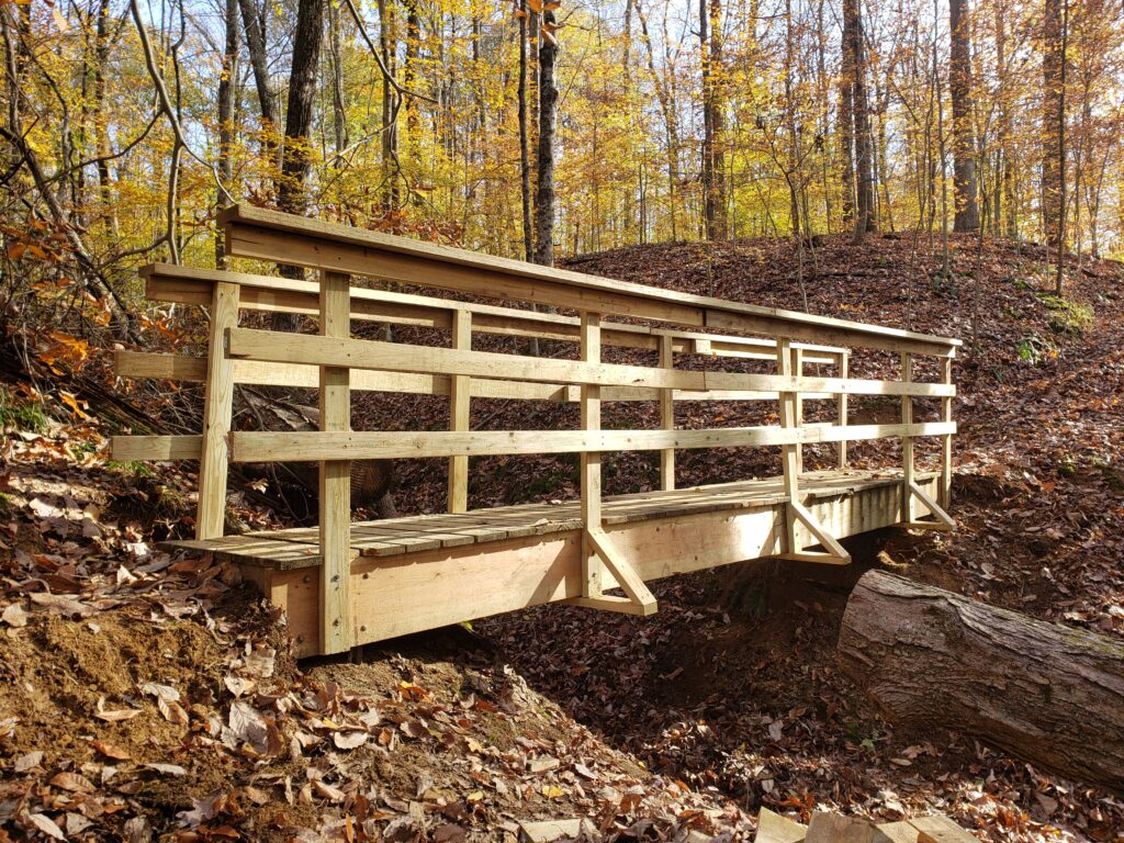
Bridge At Mile 79.3 Just North of the Frank Fisher Barn Has Been Repaired & Enhanced – Nov. 3
- During the the winter of 2020 the bridge at mile 79.3 was damaged by a large tree. Last Spring supplies were carried in to the site. On the last week of October and the first week of Nov. The bridge was repaired. Guardrails were added to the bridge which formerly did not have guardrails.
| Another Shelter Has Been Built at Mile 145.2 Thanks to the generosity of the DOF there is now a new shelter at mile 145.2. It is called the “Backcountry Shelter”. It is ready for use. |
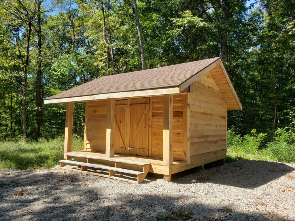 |
Indian Hill Shelter & Reroute – Mile 134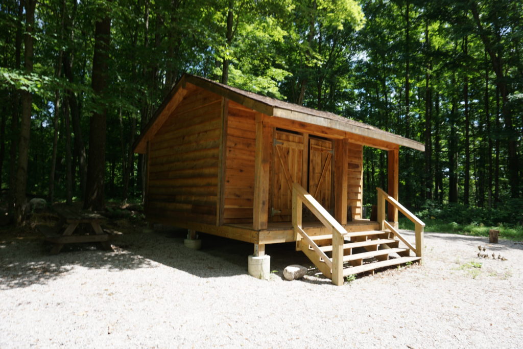
- At Indian Hill, mile 134, a shelter has been constructed by the HHC along with a reroute that takes about 1/2 mile of the trail off of Indian Hill Road. There is a trailhead parking lot where the trail intersects Indian Hill Road just South of the creek and train tracks.
KHTA Town Guide Update – May 2020
- Unfortunately, over the winter the gas station – stores at Leesville and Medora were closed. This eliminates the Leesville resupply route.
Resupply is still possible in Medora through the Post Office. Mile 64.2 Sparksville Park to Medora is 5 miles or Mile 69.7Mile Hemlock Bluffs Nature Preserve to Medora is 5.3 miles
Also, the Post Office at Norman remains available. Mile 79.2 Frank Fisher Barn is 2.5 miles to Norman or Mile 82.1 Hwy 50 is 3 miles to Norman – or Mile 86.6 Polk Patch Road (Tr 13) is 2.5 miles from Norman.
Hoosier National Forest Trail
- For conditions in the HNF, check their website at Hoosier National Forest . You can check weather conditions in the Bloomington area at Bloomington Area Weather Conditions.
Pioneer Trail
- The bridge across the White River just beyond the Sparksville County Park trailside camp can be flooded at times of prolonged rainfall.
Knobstone & Tecumseh Trail
- Trail flooding. The Knobstone Trail is more likely to be inaccessible in times of flooding in Southern Indiana because of flooded access roads than because of trail flooding. Check local weather reports and Jackson/Washington State Forest office for closure information: (812) 358-2160.
- To check on conditions on the Tecumseh Trail in the Morgan-Monroe & Yellow Forests, go to the HHC website
https://www.hoosierhikerscouncil.org/category/trail-conditions/ - Timber harvest trail closures: All areas of state forests are regularly subject to harvest rotations. Check the DNR Knobstone Trail website for detailed trail information: http://www.in.gov/dnr/outdoor/4224.htm
You may find additional at (MMSF) http://www.in.gov/dnr/forestry/4816.htm and
YSF) http://www.in.gov/dnr/forestry/4817.htm